(The science and history of the Boltonville section of the Wells River watershed)
PROJECT
DESCRIPTION
BLUE Home
- Project
Description
- Purpose
- Goals
- Program Setup
- The Program
- Expected Outcomes
- Goals
Stations & Data
Photo Gallery
CVTA Home Page
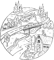
Purpose: Our project is a watershed education and monitoring program for elementary to middle school-age children to encourage the protection and study of the river. Five sessions will consider the history, impacts (both positive and negative) and mitigation of five different activities that have occurred along a short section of the Wells River over the past 150 years. Methods for quantitative monitoring and measurement of water flow and quality parameters will be taught and data collected. The program will begin with defining what a watershed is. From that definition we will discuss and evaluate the impacts on the Wells River, positive and negative, of the following events and developments in the Boltonville area of the Wells River watershed in Basin 14:
- Interstate 91
- Montpelier-Wells River Railroad bed (now the Cross Vermont Trail)
- Dairy farm
- Power station at the Boltonville Falls
- Landfill (now closed)
Goals: We will develop a river monitoring and measurement network (5 stations) above and below each of the developments. On a weekly basis throughout the spring and summer we will involve students at each station measuring river discharge (water depth and flow rate cross sections), water temperataure, pH and conductivity. A small weather station will also be established to measure precipitation and air temperature. The data will be placed on a web site and made available to the students as a basis for evaluating impacts and help determine methods to mitigate any possible negative effects of the above-mentioned events and developments.
Setting up the program: This March we began the informational meetings regarding the 5 summer "sessions" that began with learning what a watershed is. From this early session we began "recruiting" the students for the project. We met with the prospective group at least once a month through the remaining school year to prepare for the summer sessions. In April we began setting-up the river monitoring stations with the students with the help of a volunteer from the US Army Cold Regions Research Lab in Hanover, NH.
The program:
Each of the 5 summer sessions will last two days. These sessions will be scheduled during the months of June, July and August. Each day will run from 10 AM to 2 PM with the students bringing their own lunches and snacks. We will provide the student materials needed for each session (such as notebooks, pencils and other study materials). During the Fall '04 the student intern involved with the summer project will present the "findings" of the session activities (using the information that will be recorded on the new website) to the Newbury Conservation Commission.
From each session the students will develop a summary of:
- Possible or actual benefits to the environment, region and community
- Possible or actual detriments to the Wells River water quality
- Possible or actual mitigation methods or practices associated with
each of the following land uses:
- Hydro plant at Boltonville Falls:
- show students the principles of hydro generation of electricity;
- identify changes in river morphology because of the hydro plant;
- discuss flow issues;
- importance of maintaining healthy habitat for fish and other
aquatic animals and insects.
- Closed, un-lined landfill:
- discuss with students the issues surrounding waste disposal;
- importance of recycling and reducing the waste stream;
- discuss concepts of groundwater and surface water protection;
- discuss alternative methods of solid waste management.
- Developing and abandoning of railroad:
- discuss the historical importance of the Wells River/Montpelier railroad as transportation in the growth of local communities;
- discuss the impact of the building of the railroad on the natural communities in the area (i.e. river, wildlife, forest);
- discuss the current interest in rail-trail conversions (i.e.
the Cross Vermont Trail)
- Interstate 91:
- discuss how the construction of the interstate changed the course of the river, verify using old aerial photographs;
- discuss how farmland was subdivided and lost to the project;
- discuss transportation issues related to the highway system
and how these highways altered some of the local culture and
opened-up rural areas
- Dairy farm:
- discuss sustainable agriculture and local food production with local business inputs;
- farming methods that reduce erosion and run-off (i.e. rotational grazing as compared to tilling river bottom land, manure storage for farms in floodplain areas);
- importance of riparian buffers in protecting the river
- Hydro plant at Boltonville Falls:
The expected outcomes of the project include:
- Ground and surface water protection strategies
- Practices to maintain the integrity of the local dairy farm adjacent to the Wells River
- importance of protective riparian buffers that include forested areas and wildlife travel corridors
- consideration of all impacts to the river from within the watershed area
- importance of community involvement in planning concepts, remediation and implementation of all river-related projects
- developing an interest in reviewing regularly recorded data from the "river monitoring stations."
BLUE is funded by a Vermont Watershed
Grant and supported by
the White River Natural Resources Conservation District.
the White River Natural Resources Conservation District.